Surveyors are the first people to calculate and chart the land and on any construction site, it’s important that your topographical surveys are accurate, as it plays an integral role in the development of the land.
From measuring, planning, designing and setting out to building the final road, utility and landscaping require accuracy and the ability to combine a multitude of data set into one place.

The advantage of switching to GeoMax X-PAD Software is that you will be able to produce accurate data in no time.
Combining the X-PAD Ultimate field software with the X-PAD Fusion office software allows you to directly transfer data from the field to the office. The X-PAD Fusion software allows you to integrate geospatial data from any TPS, GNSS, scanners and other sensors into a single programme allowing you to create all your required documents, brand them with your company logo and email it directly to your customers.

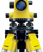
Survey Max is an authorised GeoMax dealer and can help you identify the ideal equipment for your project

Explore our products

Survey Max is a fully authorised distributor for Geomax International, part of the Hexagon group of companies.